 7 hours ago
8
7 hours ago
8
 Image source, Getty
BySimon King Lead Weather Presenter and Ben RichLead Weather Presenter
Amber heat health alerts have been issued by the UK Health Security Agency (UKHSA) with a potential heatwave set to develop this weekend.
The amber alerts cover the east, south-east and south-west of England as well as London, and are valid from 12:00 BST on Thursday until 20:00 on Tuesday.
Yellow alerts are valid across the Midlands during the same times.
Temperatures are set to climb above 30C (86F) during Friday and then again from Sunday - with the potential that some locations in the south and east of the UK may enter official heatwave conditions.
Amber heat health alerts are issued when high temperatures are likely to have a significant impact on health and social care services.
They suggest there is likely to be an increase in deaths, especially among those aged over 65 or with long-term health conditions.
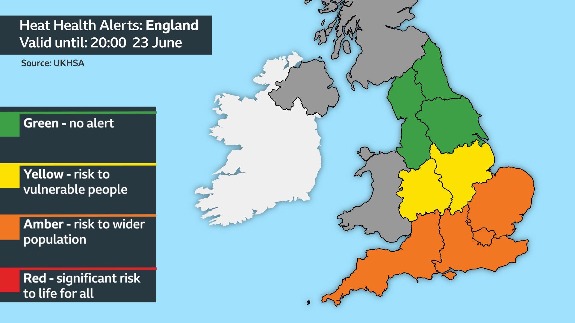 Image source, BBC Weather
Amber heat health alerts have been issued for southern and eastern England
On Thursday temperatures are expected to rise to around 25-28C (77-82F) across the Midlands, East Anglia and south-east England, where there will also be some sunshine.
A few showers are possible in the south-east, some of which could be heavy and even thundery.
Cloud and showers will affect areas further north and west, with temperatures around 17-24C (63-75F), closer to the average for mid-June.
There will be another bout of wet weather on Friday in Northern Ireland and Scotland, with some rain also affecting northern and western areas of England and Wales.
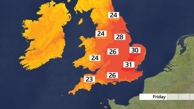
Friday will bring very high temperatures across southern and eastern England
However in southern and eastern England heat is expected to build further on Friday with temperatures potentially rising as high as 31C.
Saturday will be less hot but by Sunday and Monday temperatures will rise again, perhaps touching 32 or 33C (90-91F).
Sunny spells are likely but the heat may also spawn a few big thunderstorms.
There is uncertainty about the forecast into the middle of next week but many computer weather models allow heat to linger, especially in the south.
It is likely that some places will reach their official heatwave criteria - three consecutive days of temperatures above a threshold, which varies from 25 to 28C (77-82F) across different parts of the UK.
What is a 'heat dome' and why does it lead to high temperatures?
British weather is being influenced by a large and potentially record breaking heatwave developing across western Europe caused by a static area of high pressure.
The high pressure can act like a lid causing warm air to get trapped underneath it. This leads to already warm or hot air becoming hotter and hotter, creating a so-called "heat dome".
In the coming days temperatures across Spain, France, Germany and into eastern Europe will rise into the mid to high 30s.
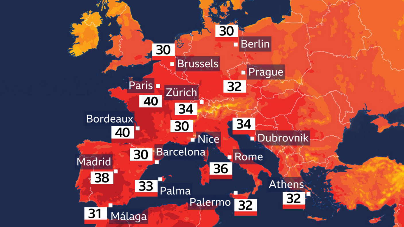
An intense heatwave is developing over Europe with parts of France expected to reach 40C on Sunday
By Sunday, temperatures could exceed 40C in parts of France, including Paris. The June temperature record of 37.6C set in 1947 is likely to be exceeded easily.
Many other locations across France could also see new records being set with this national heatwave.
The area of high pressure will subtly shift position over the next few days and this will allow some of this hot air to come into the south-east of the UK.
June heat follows record-breaking May
Last month, much of the UK faced an unprecedented heatwave, breaking the May temperature record with a high of 35.1C (95.1F) at Kew Gardens in London.
32.9C (91.2F) recorded in Cardiff was a May record for Wales, and Ireland also recorded its highest May temperature with 30C (86F) in County Clare.
According to the Met Office, the spring weather event was "one of the UK's most extreme high temperature events in our observational records".
To keep up to date with the weather forecast where you are, check the BBC Weather website or app.