 1 month ago
53
1 month ago
53
1 hour ago
Cachella Smithand Stav Danaos,lead weather presenter

 BBC Weather Watchers/SalByThePond
Geese walk along a path that has been rained on in Cromford, Derbyshire
Most parts of the UK should see mild and mostly dry weather on bank holiday Monday but heavy showers and thunder is possible in some areas.
The highs are forecast to range between 11C and 19C, down from the 23.2C that were seen on Saturday in Kew Gardens, London - the weekend's top temperature.
Scotland and Northern Ireland are expected to see the best of the sunshine during the day while England and Wales will remain mostly cloudy, with southern parts at the risk of downpours.
The rest of the week is set to feel cooler, with variable cloud, occasional sunshine, and a few showers, mainly across northern parts of the UK.
Weather for the week ahead
Despite the sunny start to Saturday, the weekend has overall remained considerably cooler than the Met Office's record for the warmest May Bank Holiday weekend when 28.7C was reached at Northolt in London in 2018.
On Sunday afternoon, most of England was dry, but overcast, following some rain across the north of the country during the morning.
The best of the sunshine was continuing across South Wales, the southern Midlands, and southern England - although a scattering of showers could later develop in these areas with the potential of heavy and thundery conditions.
Most areas will remain dry into Sunday night with temperatures unlikely to fall much below 5-10C.
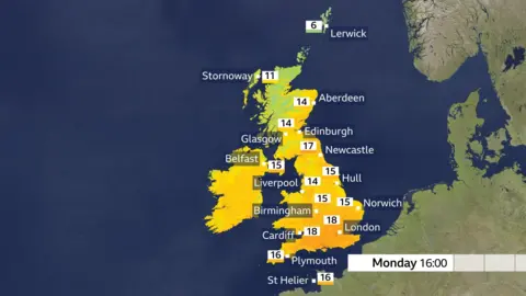
The expected temperatures highs forecast for Monday indicate areas in the south could see 18C while other parts of the UK remain cooler
For the Spring Bank Holiday on Monday, Scotland and Northern Ireland will see the best of the sunshine, although northern Scotland could catch a few showers into the afternoon.
England and Wales will remain mostly cloudy, and while southern England and South Wales are likely to see sunny spells develop, some heavy and thundery showers could be triggered.
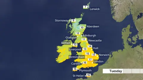
Meanwhile, temperatures are due to drop next week with Wednesday looking to be the coolest day when highs are forecast to be just below 10C in the north, and around 15C in the south - below average for the time of year.
Thursday is set to also be cool but a degree or two higher than Wednesday.
There could be a few showers - mainly across northern parts of the UK.
On Saturday evening, a funnel cloud was spotted over Scotland.
The weather phenomenon is seen from time to time and is most likely to be spotted in the UK during spring.
 BBC Weather Watchers/Kas
A funnel cloud was spotted over Scotland on Saturday evening.
A funnel cloud is a rotating, cone-shaped column of air that extends downward from the base of a cloud but, unlike a tornado, does not reach the ground.
They can become a tornado if it extends all the way to the surface.