 2 months ago
72
2 months ago
72
Nick Beake,BBC Verify USA Correspondent and Thomas Copeland,BBC Verify

 BBC
BBC
With power down, problems with communications and navigating parts of the island treacherous, the authorities in Jamaica have not yet been able to give a detailed assessment of the damage inflicted by Hurricane Melissa.
But the devastating impact of the Category 5 storm on communities is starting to be revealed by satellite imagery.
BBC Verify has been examining the new images to try to piece together what has been destroyed and what has been left standing.
Black River
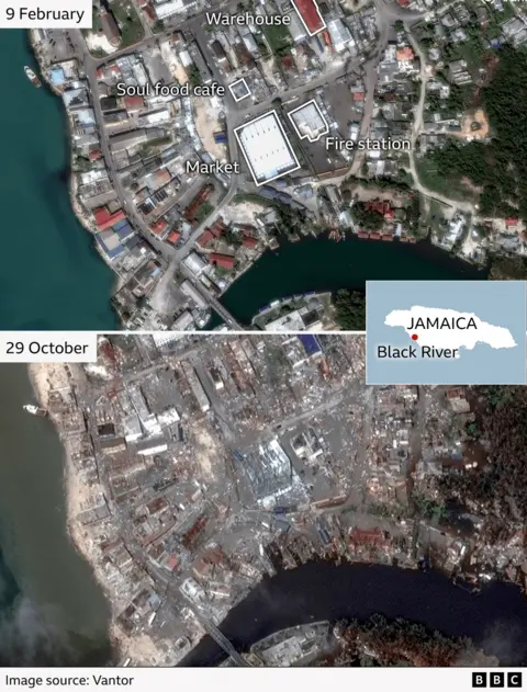
Arguably the most striking impact can be seen in images of the southwestern coastal port of Black River.
We can identify specific buildings that have been battered or in some cases destroyed.
By comparing a satellite image taken on 9 February with one taken on 29 October - after the hurricane hit - you can see that the distinctive white roof of a building housing a market has been replaced by a gaping hole.
A little further north, a café has been wiped off the map.
At the top of the image, the red roof of a warehouse has disappeared.
The outline of the fire station next to the market is still visible but the top of the building appears to have been torn off.
Jamaica's Prime Minister Andrew Holness has described Black River as "ground zero" after sharing footage of the destruction there.
White House
Photographs of White House, a fishing village on the west coast of Jamaica which is home to several thousand people, reveal how it bore the brunt as Melissa made landfall with winds of up to 185 mph.
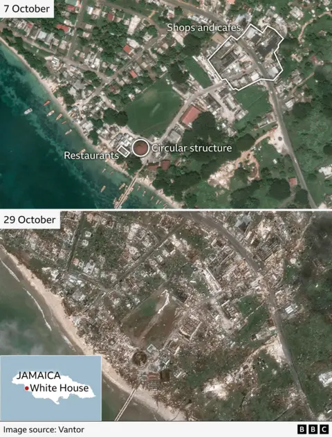
Nearly every structure appears to have been damaged or destroyed.
In particular, the buildings next to the beach appear to have razed to the ground.
These include restaurants called Marva's and Pelican Lookout.
The top of a large circular structure is now missing and further inland, along the main road, a cluster of shops has been hit hard.
Fishing boats in the bay - seen in satellite imagery on 7 October - have disappeared.
Montego Bay
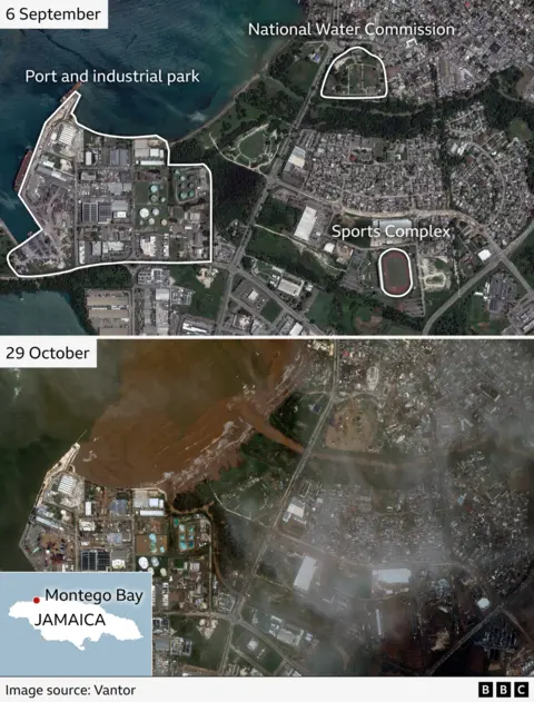
Part of of Montego Bay - one of Jamaica's most popular tourists destinations - now resemble a brown swamp.
The shore on this section of the northwest coast has been transformed by the flood water which now stains the beach.
Authorities say facilities at the port and industrial park were inundated.
The container terminal, an oil storage facility and nearby water treatment plant were all badly affected, along with a sports complex.
The mayor of Montego Bay, Richard Vernon, has called the place "devastated" and added that locals are doing all they can to look after each other.
Montego Bay is a popular destination for cruise ships to dock and home to golf courses as well resorts next to the normally pristine white sand.